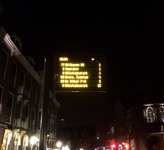
It's almost midnight. You went to Pub Night with new friends from the women's club you joined when you moved to the Netherlands, and you need to catch a bus home. You don't want to wait at the bus stop in the cold for too long. What do you do? Check Google Maps! Type in where you are going, use current location for your departure address, and then hit the icon for mass transit (looks like a train). Voila, you're given a list of choices with times. Click on one, and the map will indicate the route of the bus or train with a solid line, and any walking you may have to do with a line of circles. If you are directionally challenged...
...like me, you'll really appreciate the little blinking dot that lets you know where you are! I actually started walking in the wrong direction after getting off of a bus a few weeks ago! As you can see from the sign above, I got to the bus stop with a minute to spare. I have to admit though, sometimes buses are late; just last week I spent 14 additional minutes waiting for a bus after a scrapbooking event!
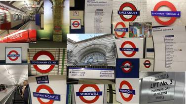
I only recently started using Google Maps, but was curious to see if it was connected to the Mass Transit system in other cities I know. I checked London, Athens, Baltimore, and Orlando, and it's a go! But, you don't have to be catching a bus. Use Google Maps when determining a route for driving, walking, or even biking--yes, I'm still trying to do more of that here in Utrecht!
I only recently started using Google Maps, but was curious to see if it was connected to the Mass Transit system in other cities I know. I checked London, Athens, Baltimore, and Orlando, and it's a go! But, you don't have to be catching a bus. Use Google Maps when determining a route for driving, walking, or even biking--yes, I'm still trying to do more of that here in Utrecht!
 RSS Feed
